
Historic Trail of Tears Connects Polk Homeschool Families
Historic Trail of Tears Connects Polk Homeschool Families
by Dony & Kathryn Donev
During the past 10 years Polk County, TN has seen a shift in its demographics with an insurgence of families from New York, Florida, California and even Eastern Europe. The latter location is perhaps overlooked not officially recorded having the most complex reasoning behind the numbers. One explanation could be adoptions or perhaps another could be due to immigrants being attracted to Gateway Cities. Such are the larger towns as Bonita Springs, Cape Coral, Fort Myers and Sanibel areas of Florida. In California these would be Cerritos, South Gate, Long Beach or Sacramento. And of course New York City provides the ultimate gateway. Therefore, these individuals are simply recorded as being from these Gateways.
Many of these families which have sought refuge, so to speak, in rural areas are ones that homeschool. But this is not the reason for this article; for it is only natural that one leaving a busy urban area would naturally want to get away from all aspects of city life and create a more intimate learning experience for their children. Such is readily available through the natural amenities and safe seclusion along the original Trail of Tears which had many routes and roundup or dispersion points other than the three main roads which are thought of first. One of them just happens to be in Polk County, TN described below.
The Georgia Road or present day Federal Road was a route of the Trail of Tears with the Tellico Blockhouse as its starting point. The route ran from Niles Ferry on the Little Tennessee River near the present day U.S. Highway 411 Bridge, southward into Georgia. The road continued southward via the Federal Trail connecting to the North Old Tellico Highway past the present site of Coltharp School, intersected Tennessee Highway 68 and passed the site of the Nonaberg Church. East of Englewood, Tennessee it continued on the east side of McMinn Central High School and crossed Highway 411 near the railroad overpass. Along the west side of Etowah, the road continued near Cog Hill and the Hiwassee River near the mouth of Conasauga Creek where there was a ferry near the site of the John Hildebrand Mill. From the ferry on the Hiwassee River, the road ran through the site of the present courthouse in Benton, Tennessee. It continued south on Welcome Valley Road and then crossed the Ocoee River at the Hildebrand Landing. From this point, the road continued south and crossed U.S. Highway 64 where the Ocoee Church of God is currently located. Proceeding south near Old Fort, the route crossed U.S. Highway 411 and came to the Conasauga River at McNair Landing. Near the south end of the village of Tennga, Georgia stands a historic marker alongside Highway 411, which states the Old Federal Road was close to its path for the next twenty-five miles southward. This is some 15 miles from the historic Chief Vann Plantation. It would have been at this point in Tennga that the Trail of Tears would have taken a turn onto GA-2 passing the Praters Mill near Dalton Georgia to connect in Chattanooga.
The reason for this article is to make the connection which goes deeper than simply establishing the Hildebrand Crossing route with Welcome Valley and Old Federal roads as the connecting path of one of the last detachments of approximately 1,200 with the original Trail of Tears. A careful reader would quickly discern the obvious geosocial connection between the new homeschool families in the Polk area and the historical Trail of Tears, which was brought to light in a recent discovery in the Polk County TN Homeschool Network. Nearly a dozen of these families, which in the last decade made their journey to rural living in Polk County live nowhere else, but along the historic trail. Coincidence? Perhaps. Planned? Doubtfully so because most were not aware of this information as this route of the Trail is not a popular one and as such has remained virtually enigmatic. Now, we are in a quest for the logic behind such happening as well as to see if there are other Polk Homeschoolers that happen to also live along this route. If you have any contributing information to this ongoing project, we would love to hear from you. Visit us at www.PolkHomeschool.com or reach out to [email protected].
Historical Significance of the Tennessee/Georgia Old Federal Road in the Trail of Tears and its Connection to the Church of God
 Historical Significance of the Tennessee/Georgia Old Federal Road in the Trail of Tears and its Connection to the Church of God
New Echota, Georgia was the capital of the Cherokee Nation from 1825 to 1838. This is the location where the Treaty of New Echota or the Treaty of 1835 was signed on December 29, 1835 by U.S. government officials and representatives of a minority Cherokee political faction called “The Treaty Party” or “Ridge Party”. This treaty was not approved by the Cherokee National Council nor signed by Principal Chief John Ross. Regardless, it established terms under which the Cherokee Nation were to receive a sum not exceeding five millions dollars for surrendering their lands and possessions east of the Mississippi river to the U.S. Government and agreeing to move to the Indian Territory west of the Mississippi River, which later became part of Oklahoma.
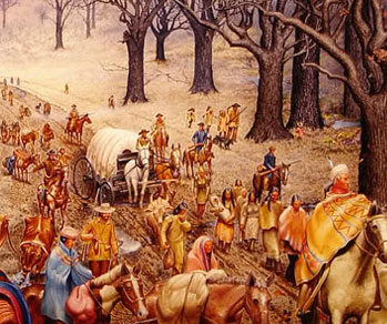
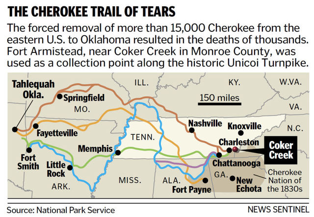
The Red Clay State Historic Park, located 17 miles southwest of the Church of God Headquarter in Cleveland, Tennessee, marks the last location of the Cherokee councils where Chief John Ross and nearly 15,000 Cherokees rejected the proposed Treaty of 1835. Despite the questionable legitimacy of this Treaty, in March 1838, it was amended and ratified by the U.S. Senate and became the legal basis for the forcible removal of the Cherokee Nation known as the Trail of Tears. The name came from the Cherokees who called the removal “Nunna-da-ul-tsun-yi,” which means “the place where they cried.” The last pieces of land controlled by the Cherokee Nation at that time were North Georgia, Northern Alabama and parts of Tennessee and North Carolina. The forced journey was through three major land routes. Each route could have taken some 1,000 miles and over four months to walk. The removal of the Cherokees and other tribes from their homelands in the Southeast began May 16, 1838.
The Georgia Road or present day Federal Road was a route of the Trail of Tears that the Cherokee people walked during their forced removal from their homelands. The route was built from 1803 to 1805 through the newly formed Cherokee Nation on a land concession secured with the 1805 Treaty of Tellico with the agreement that the U.S. Government would pay the Cherokee Nation $1,600.00. The Treaty was signed on October 25, 1805 at The Tellico Blockhouse (1794 – 1807) – an early American outpost located along the Little Tennessee River in Vonore, Monroe County, Tennessee that functioned as the location of official liaisons between the United States government and the Cherokee. The route was originally purposed to be a mail route because of the great need to link the expanding settlements during the westward expansion of the U.S. colonies. It was in 1819 after improvements to the road that it was called “the Federal Road”.
The Tellico Blockhouse was the starting point for the Old Federal Road, which connected Knoxville to Cherokee settlements in Georgia. The route ran from Niles Ferry on the Little Tennessee River near the present day U.S. Highway 411 Bridge, southward into Georgia. Starting from the Niles Ferry Crossing of the Little Tennessee River, near the U.S. Highway 411 bridge, the road went straight to a point about two miles east of the present town of Madisonville, Tennessee. This location is 20 some miles north of the Tellico Plains area that marks the site of the beginning of the Church Cleveland, Tennessee. The road continued southward via the Federal Trail connecting to the North Old Tellico Highway past the present site of Coltharp School, intersected Tennessee Highway 68 for a short distance and passed the site of the Nonaberg Church. East of Englewood, Tennessee it continued on the east side of McMinn Central High School and crossed Highway 411 near the railroad overpass. Along the west side of Etowah, the road continued near Cog Hill and the Hiwassee River near the mouth of Conasauga Creek where there was a ferry near the site of the John Hildebrand Mill. From the ferry on the Hiwassee River the road ran through the site of the present Benton, Tennessee courthouse. 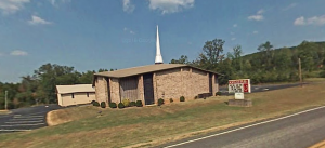 It continued on Welcome Valley Road and then crossed the Ocoee River at the Hildebrand Landing. From this point the road ran south and crossed U.S. Highway 64 where there is now the River Hills Church of God formerly the Ocoee Church of God. Continuing south near Old Fort, the route crossed U.S. Highway 411 and came to the Conasauga River at McNair Landing. Near the south end of the village of Tennga, Georgia is an historic marker alongside of Highway 411m which states the Old Federal Road was close to its path for the next twenty-five miles southward. It would have been at this point in Tennga that the Trail of Tears would have taken a turn onto GA-2 passing the Praters Mill near Dalton Georgia to connect in Chattanooga, Tennessee.
Out of the 15,000 Cherokee who endured the forced migration west after the Treaty of 1835, it is estimated that several thousand died along the way or in internment holding camps. This Old Federal route is where some of Cherokee holding camps would have been located. The Fort Marr or Fort Marrow military post constructed around 1814 under the 1803 Treaty, is the last visible remains of these camps. The original fort was built on the Old Federal Road near the Tennessee/Georgia state line near the Conasauga River. It was relocated in 1965 beside U.S. Hwy. 411 in Benton and then to it’s current location in the Cherokee National Forest on the grounds of the Hiwassee/Ocoee State Park Ranger Station at Gee Creek Campground in Delano, Tennessee. This location provides access to popular Church of God water baptismal sites. In June 4, 1838 Captain Marrow reported having 256 Cherokees at his fort ready for emigration.
The Native Americans were forcefully removed from their homes, plantations and farms all because of greed. Thousands of people lost their lives including the wife of Chief John Ross. Parts of the Old Federal Road have been washed away with floods of tears, but there are parts that still remain. The Church of God, having its roots in the same territory of the Cherokee, Chickamauga, Muskogee Creek, Choctaw and Chickasaw people, plays a vital role in the process of reconciliation among the descendants of the Trail of Tears. And the historical buildings and markers along the Trail or Tears must be preserved. The churches along the route even though they were not actual structures during the time period are a historical beacon of hope which still crying out for those lost on this tragic journey.
The Old Federal Road and the Cherokee Trail of Tears
The Old Federal Road: Researched & composed by Allen Parke Swayne & James Parke Swayne
During the westward expansion of the original colonies, both north and south of the Cherokee Nation, there was great need for a mail route to link the expanding settlements. Since the Cherokee Nation occupied the area from the mountains of North Carolina westward to Red Boiling Springs in middle Tennessee, the United States settlements in Georgia could not communicate with anyone living in Virginia. The idea of negotiating with the Cherokee for a mail route from Knoxville to Augusta, Georgia may have started as early as 1792 when George Washington began his second term as president.
The route was obtained in 1806 with the agreement that the U.S. Government would pay the Cherokee $1,600.00 and was known by The Tellico Treaty. The route was laid out by a party of Indians and whites and it ran from Niles Ferry on the Little Tennessee River, southward into Georgia. The area went through the land occupied by the Cherokee Nation and the route took advantage of favorable terrain for travelers.
The actual construction of the Old Federal Road was apparently done by the Indians who also ran the ferries crossing the Hiwassee and Ocoee Rivers. The excellent choice of right-of-way is impressive from an engineering standpoint. From Niles Ferry to Conasauga it does not deviate as much as one-half mile from a straight line. It follows low-shale ridges in most places and it following creeks and swampy areas.
Starting from the very old Niles Ferry Crossing of the Little Tennessee River, near the present U.S. Highway 411 bridge, the road went in an almost straight line to a point about two miles east of the present town of Madisonville. Here in 1828, the newly created Monroe County erected its first courthouse on what is now the Ross Jewell farm. It was a two-story log building with the jail on the top floor.
The road continued southward past the present site of Coltharp School, intersected Tennessee Highway #68 for a short distance and passed the site of Nonaberg Church. East of Englewood, it continued on the east side of McMinn Central High School and crossed Highway #411 near the railroad overpass. Apparently, when the railroad was built, a road just on the east side of the tracks leading into Etowah was called the Old Federal Road. This has caused some confusion as to location but it is well established that the original road came near Old Williamsburg and ran through the Doug Tullock property. By keeping on this route, it missed the low ground and swampy conditions that were typical of the Etowah area and its vicinity.
Keeping on the higher ground along the west side of Etowah, the road continued near Cog Hill and the Hiwassee Riber, near the mouth of Conasauga Creek. It may have passed through the town of Columbus, but it is more likely that the ferry was farther downstream. Columbus was the first county seat of Polk County and at one time it had a hotel, two stores and two churches. The little town faded out of existence after the Ocoee Purchase of 1835, when Benton was chosen for the county seat. The last empty building was used in 1860 by the U.S. Army to build a pontoon bridge across the Hiwassee River so that troops could be moved toward Chattanooga.
Three grave sites remain on the hill overlooking the old town site of Columbus. They are of Col. Henry Bradford, 1776/1871 and his wife Rachel Farland Bradford and Stanwix Hord, son of Col. Hord. These graves sites are easily found in this area, although they were untended for years and were in a deplorable condition until restored and fenced in 1995.
About a mile up Conasauga Creek from its mouth is the site of the Hildebrand Mill. It was built about 1807 by the U.S. Government for the Cherokee Indians. John Hildebrand was of German descent and was manager of the first hotel in Knoxville when he was hired to build a grist mill for the Indians at a mutually satisfactory site. The site on Conasauga Creek was selected and the mill was constructed. Hildebrand married a Cherokee woman and raised his family in Polk County.
From the ferry on the Hiwassee River the road ran through the site of the present Benton courthouse. It followed the site of the Welcome Valley Road for some distance and then crossed the Ocoee River at the Hildebrand Landing. One of the Hildebrands built a fine house on the south side of the Ocoee River. This dwelling still exists although it has been moved a short distance. It was owned by Mr. & Mrs. Willis Trew but has been deeded to the Polk County Historical Society upon the death of the present occupant.
From Hildebrand Landing the road ran south and crossed U.S. Highway #64 at a point where there is now a Church of God. Continuing south near Old Fort, it crossed U.S. Highway #411 and came to the Conasauga River at McNair Landing. The McNairs were part Cherokee and were moved out on the Trail of Tears in 1838. The McNair gravesite was still in existence in 1950.
Since the Hildebrand Landing on the Tennessee-Mississippi Rivers system the Old Federal Road was used as a portage route to cut off over a thousand miles of travel from the water route to Mobile Bay. Heavy carts pulled by oxen moved boats from Hildebrand to McNair. One cargo boat was reported to carry one hundred barrels of flour and whiskey, but the proportion of each was not given. A proposal to build a canal to replace the portage was found to be not feasible.
Near the south end of the village of Tennga, Georgia is an historic marker alongside of Highway #411 which states the Old Federal Road was close to its path for the next twenty-five miles southward.
Besides the developments already mentioned, there were several other historic sites that were built near the Old Federal Road. A few of these are as follows:
- Vastine Stickley House in Madisonville
- Cantrell Grave near Etowah
- Nonaburg Church near Englewood
- Etowah Depot
- Cog Hill Seminary near Etowah
- Trew’ Store near Etowah
- Old Fort blockhouse in Benton
- Carlock Academy near Etowah
- Methodist Campground near Etowah
- Williamsburg near Etowah
- Half Moon Sotre in Monroe County
- Ho Store in Monroe County
- Sequoyah Birthplace museum near Vonore
- Hildebrand landing to McNair Landing, portage route in Polk County
As we have traced the history and route of the Old Federal Road, it has been found to be one of the most important sites which aided in the historical development of the States of Georgia and Eastern Tennessee. Please make some allowances for the hand-drawn path on the map above. It does deviate a small amount from the actual path.
- Coltharp School and Coltharp Community so called after the Coltharp family…many of which still reside in the area.
- Nonaberg Church still active.
- The Hildabrand lineage is well documented by several people…all of altering heritages, African-American, White & Cherokee. For more information please email [email protected] This family had marriages within the Mayfield, Starr & several other families in the area.
- The Church of God spoken of is “Ocoee Church of God”.
- The Old Fort Blockhouse spoken of originally stood approximately 1 mile north of McNairs Ferry. In the mid 1950’s the building was moved from its original location to its current location near the Polk County Jail in Benton, TN.


